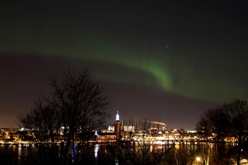
Northern Lights – Aurora borealis over Stockholm, 17 March 2013
Northern Lights – Aurora borealis over Stockholm, 17 March 2013

Statistics on the oil spill based on 50,000 barrels per day spilled and 8 hour work days. Graphs made using interpretation of data from: http://www.deepwaterhorizonresponse.com/go/doctype/2931/53339/ and http://www.usgs.gov/deepwater_horizon/ and https://www.cstars.miami.edu/ . The amount of dispersed oil is poorly constrained and the total recoverable amount is also poorly known. Hurricane Alex will likely raise the sea level 1.5 meters or so and this will create big problems ashore....The effect of Alex can already be seen in the slow down of the capture rate revealed in the stats above. .(Ed. 25 August - as it turned out, Alex hampered cleanup efforts, but not much reported on effects at the shore).

Digitally hand coloured black and white photo. Copyright 2010 Robert Corkery

50,000 barells per day with a proportion of this dispersed with detergents has probably contaminated 100's of millions to billions of gallons of water in the Gulf of Mexico. Sea life ecological communities could be in real danger. There could be a giant burst of microbes on its way. Lets hope the hurricanes hold off for a while longer.

Over two hundred small earthquakes occurred under the Eyjafjallajökull volcano during the first half of May 2010 according to the Iceland Mat Office. These have come in a series of swarms. Katla seems to have been shaken by only two or three small quakes in the same period. The Eyjafjallajökull quakes have all been relatively small - between Ml 0-3.0 when measured on the local version of the Richter scale. The Katla earthquakes seem to indicate nothing other than normal seismic activity, for now. Although the above graphic is not strictly scientific because the data are preliminary and of variable quality, it shows that the locations of the earthquakes clearly define the main magma conduit rising from over 30km depth to the surface. Earthquake specialists will only assign exact locations to the earthquakes after they have carefully examined all the data and account for the effect of complex geology on the travel times of the seismic waves. This careful analysis has not yet been published. For now these earthquakes indicate that magma is probably moving at great depth along one main vertical feed system, and unless there is some blockage of that pathway, will continue to refresh the magma chamber. The preliminary earthquake data used in this picture were published from 3rd-16th May 2010 on the website of the Iceland Meteorological Office. http://en.vedur.is/earthquakes-and-volcanism/earthquakes/myrdalsjokull/#view=map

9 May 2010. The gas hydrate I structure is one of the likely possible gas hydrates clogging the "Macondome", the containment dome being lowered by BP to control the Macondo oil well under the Deepwater Horizon rig in the Gulf of Mexico. This sets back the containment date. Gas hydrates are crystals of water and gas. The gas in this case is probably hydrocarbon gas. The transparent black balls above represent the gas molecules trapped in the cages of the water-ice and gas structure. These gas hydrates form a vast reserve of future fuel, but are ironically the enemy in this case. They form when four things are right - that is you need water, gas, cold temperature and high pressure. Gas hydrates burn when ignited. Were gas hydrates involved in the initial explosion? Did they form in the blowout preventer (BOP)? The BOP is a Hydril 18¾ inch 15,000 psi, six-ram system with a Cameron 15,000 psi wellhead connector, apparently, and currently in a state of disastrous disrepair! Crystals of these flammable ice form on surfaces, and thats the problem with the containment effort. The dome is getting coated with gas hydrate crystals . Surface active agents (detergents) can prevent the clogging. So can glycols and other chemicals. What will BP do?

The Earth shook directly under Mount Katla in Iceland when a small earthquake (magnitude 1.5) was detected at about 6 km depth on Wed 28th April 2010. Is the giant awakening? UPDATE: Another earthquake occurred under Katla. The original 28th April 2010 earthquake is now being reported as two simultaneous earthquakes, one at 7.1 km (magnitude Ml=1.0) and another at 0.5 km depth (Ml=1.5). Heidi Soosalu writing on Katla seismicity (Journal of Volcanology and Geothermal Research, vol 153 177-186, 2006) states that Katla has seasonal earthquake activity. These tremors usually occur later in the year probably because of changes in glacial melting and groundwater pressure in the roof of the caldera. Seismic shocks shake two distinct areas of Katla, the Goðabunga rise on the west side, and the caldera area in the center of Katla. The latest two earthquakes are associated with the rim of the caldera. A third earthquake occurred today on the southern slopes of Katla (magnitude 1.7 at about 7km depth). Since 2002, seismic activity has been fairly continuous over and above the seasonal effect, particularly on the Goðabunga rise during 2001-2004. However a seasonal effect is still evident - earthquakes are less frequent in winter. The increased seismic activity since 2001-2002 is attributed to acceleration of a rising dome of highly silicic, viscous magma 1.5km down stressing and deforming the roof above it. Inflation of the volcano and increased geothermal activity have accompanied the increased seismicity since 1999. Because of the rising dome under Goðabunga rise, several eruption scenarios are worth considering besides the more "traditional" basaltic eruption from the caldera. These include a more silicic style event, a type that has not occurred in Katla for more than 1700 years, and could be extremely violent. Seismicity preceding silicic eruptions have been noted by Soosalu et al 2006 at Unzen in Japan and in the Soufrière Hills of Montserrat in the context of a silicic Katla eruption. The good news so far is that the current seismicity cannot be easily attributed to anything but ongoing activity started in 1999. Signs of an imminent eruption will include further increases in hydrothermal activity and ground uplift - neither of which have been reported as anomalous so far. The not so good news is that post-1999 earthquakes shout loudly at us to not ignore the slumbering beast, and accept the possibility that an explosive eruption from the Goðabunga rise on the west side of Katla could be more than a little bit bigger than the current Eyjafjallajökull eruption! Image © Robert Corkery 2010.

